Notice

I am working on the template of this blog today in order to chase down some problems that have developed with my template and widgets.

Macon County Commissioners

Coverage of the meetings of the Macon County Board of County Commissioners.

Franklin Town Board of Aldermen

Coverage of the meetings of the Franklin Town Board of Aldermen.

Macon County School Board

Coverage of the meetings of the Macon County School Board.

Photoblog

Photos from my photoblog.

nullspace for future use

nullspace for future use

About

Showing posts with label Preparedness. Show all posts

Thursday, June 16, 2022

President's Column | It’s Important to Be Prepared and Make Smart Choices When You Engage in Summer Fun

School is out and summer is here! Summer brings busier schedules and we become more adventurous, getting outside and engaging in activities like hiking, biking, and swimming. If you’re like me, these fun pastimes also bring on muscle aches and bruises in places I didn’t even know existed.

In addition to the fun, being outdoors more puts us at higher risk for broken bones, sunburn/poison, insect bites, injuries, and the complications associated with them. A sudden increase in vigorous physical activity can also contribute to a more serious health problem, like a heart attack or stroke. Just like when we encourage individuals not to be “weekend warriors” and shock their bodies with sudden, overly challenging physical activity — like when people rush out in the winter to shovel vast amounts of heavy snow — we should also take it easy when we start being more active in the warmer months. It’s always good to gradually work up to a higher rate of activity intensity. In other words, it’s better to start out walking and gradually progress to a short run, and so on, so you can avoid being that 1 in 6 individuals who suffers a heart attack.

A major concern in this beautiful land of lakes and waterfalls is water safety. Although I can get spooked thinking about the slithery creatures lurking beneath the water’s surface, they’re not what cause the most injury and death. It’s swimming, which poses a 1 in 1,024 chance of death. Drowning and something called “dry drowning,” a serious condition where a person experiences a lung injury and muscle spasms due to water aspiration, present serious risks to swimmers. Dry drowning doesn’t look like what we think of as drowning, because it can happen very fast and only requires a small amount of water to do its harm. Remember to practice good water safety techniques when you decide to venture into any body of water. This means having swimming mastered and wearing a life jacket if you’re canoeing, kayaking, paddle boarding, or boating.

And no matter what fun summer activity you participate in — even if it’s laying in a chaise by the pool and reading — never underestimate the power of the sun. It’s important to keep yourself well hydrated with an ever-present water bottle and to use UV-blocking sun protection in the form of a sunscreen that has a strength of at least SPF 30. It’s safer to limit your direct exposure to the sun and seek shade during the “prime” sun intensity hours of between 10am and 4pm.

Outdoor lovers also have a 1 in 6,368 risk of death from sunstroke, or heatstroke, a serious condition caused by sustained sun exposure in high temperatures and lack of hydration. Symptoms of heatstroke include a temperature of 104 degrees or higher (a true medical emergency that requires immediate care), headache, dizziness, red, hot skin, and a lack of perspiring. You may also experience nausea or vomiting, rapid heart rate and breathing, and muscle cramping. I can’t emphasize enough that if you have any of these symptoms, it’s critical to get to an Emergency Department as soon as possible.

If you’re doing yard work, biking, or hiking, insect bites and stings can be more than a nuisance, especially if you have an allergy. Those allergic to bee stings should always be equipped with an epinephrine pen, which prevents you from going into anaphylactic shock, a life-threatening condition.

Mountain biking and hiking in our beautiful mountains are also associated with various risks. Try to go hiking with a buddy, remember your cell phone as it’s equipped with GPS capabilities, and don’t forget water, snacks, and a jacket. Stay up-do-date on weather conditions, so you don’t find yourself in the path of a storm, and take care to avoid an ankle sprain by steering clear of slippery surfaces like wet, moss-covered rocks. Finally, be mindful of waterfall safety by reading posted warning signs well and following their guidelines. Waterfall accidents cause a number of deaths each year in western North Carolina.

The good news is that these summer-related health issues are preventable, simply by following safety guidelines, being familiar with each condition’s symptoms, and knowing what to do if you or someone you’re with experiences them. In short, remember to drink water, slather on the sunscreen, wear your protective gear like sunglasses, bike helmets, and life jackets, and stay aware of your surroundings.

If you run into trouble or need medical attention this summer, don’t delay seeking it. A call to 911 initiates a chain of care that’s more successful the earlier it starts. It has the power to improve the continuity of efficient, effective care you get once you reach Angel Medical Center (AMC), and so does providing your caregivers with an accurate medication list and medical history information.

In June, we also recognize Men’s Health Month, National Nursing Assistants Week (June 16- 22), Health Care Risk Management Week (June 20-24), and National Safety Awareness month, all good things to celebrate.

I hope you enjoy getting out this year, remember to stay safe, and if you need us, know that AMC is your center for both community emergency care and total health care.

About Clint

Clint Kendall, FACHE, MBA, MSN, BSN, RN, is Chief Executive Officer/Chief Nursing Officer of Angel Medical Center. He started his career as a nurse, and that perspective still informs his work and passion for the patient experience. Clint holds a Master’s Degree in Business Administration, Nursing, and Health Care Management from the University of Phoenix, and a Bachelor of Science in Nursing from Western Carolina University. He comes to Angel Medical Center from Andalusia, Alabama, where he served as Chief Executive Officer of Andalusia Health, part of LifePoint Health. Clint has also earned the Certified Professional in Patient Safety (CPPS) certification, and is a member of the American College of Healthcare Executives (ACHE), the American Organization of Nurse Executives (AONE), and the American Nurses Association (ANA).

Monday, May 23, 2022

NCDOT Has Developed Early Flood-Warning System for Roads
Agency also readies supplies, preps employees ahead of the hurricane season


---BEGIN SPONSOR SEGMENT---


Weather Sponsor


Adams Products, a Division of Oldcastle is underwriting the daily weather briefing & public safety updates for the month.

Open 7:30 AM to 4:00 PM, M-F, located at 895 Hickory Knoll Road, Franklin, NC. Visit our Facebook page at: https://www.facebook.com/Adams.Oldcastle.Franklin.NC

All your masonry needs are available. Our phone number is 828.524.8545, the public is welcome, we̢۪ll help you with your next project.


DAY SPONSOR

Young Tree Service is sponsoring Macon Media for today.

They provide complete tree care, are licensed and insured. Specializing in low ground impact. Danger tree removal. Crane Service, Pruning, Views, 24 hr emergency service. Call 828-421-0967 or visit Young Tree Service for more information.

---END SPONSOR SEGMENT------


RALEIGH – When the next hurricane strikes, the N.C. Department of Transportation will be armed with an advanced flood-warning system that relies on a network of 400 river and stream gauges.

The new system will allow the NCDOT for the first time to analyze, map and communicate in real-time any flood risks to roads, bridges and culverts. 

This critical information will go to NCDOT maintenance staff responding to flooded roads and washed-out culverts; and it will benefit local emergency management officials and the public accessing the department’s DriveNC.gov website for timely weather-related closures.

“This state-of-the-art warning system our department has created will help us be better prepared for the next major storm,” Transportation Secretary Eric Boyette said. “Even though we’ve had some quiet hurricane seasons recently, we cannot let our guard down.”

The last major storm to impact the state’s road network was Hurricane Florence in 2018. Researchers at N.C. State University and the National Hurricane Center are predicting an above-average hurricane season, which officially starts June 1.

Armada of flood gauges

After Florence, the state Legislature gave the NCDOT a $2 million grant to develop sophisticated software and install more flood gauges. The system, however, mostly taps into existing gauges operated by other agencies, such as the N.C. Emergency Management and the U.S. Geological Survey. The system includes an interactive online dashboard and flood mapping based on three-dimensional ground surveys. 

One part of the new early flood-warning system covers almost 3,000 miles of state-maintained roads, mostly east of Interstate 95. The system also will allow NCDOT to monitor flood conditions for some 15,000 bridges and culverts statewide. The agency’s Hydraulics Unit has been fine-tuning the system and training staff on it with smaller storms over the past year. 

In addition, the NCDOT has formed a recent partnership with the University of North Carolina at Chapel Hill’s Renaissance Computing Institute and the U.S. Department of Homeland Security’s Coastal Resilience Center of Excellence to receive forecast modeling data on how storm surge may affect the state’s road network in coastal areas.

Maintenance crews ready

The NCDOT has been preparing for the hurricane season in other ways. The agency has been reviewing procedures and conducting exercises internally and with partner agencies.

Some highway divisions with coastal counties held employee training events this spring to review response and recovery operations. All of the agency’s 14 highway divisions also have been taking inventory of supplies, doing maintenance on chainsaws and other equipment, and readying emergency on-call contracts that will supplement what NCDOT employees do in responding to a storm. 

Public preparations

State transportation officials remind people now is the time to prepare supplies for the possibility of an extended power outage, restricted traveling, or the need to be at a shelter. The N.C. Emergency Management maintains a comprehensive list of items to include in an emergency supply kit.

After the storm has passed, people should remember to never drive through flooded waters or around barricades. It only takes one foot of water to sweep a vehicle away.

For more preparation tips, including evacuation routes and evacuation zones by coastal county, visit ReadyNC.org and also watch this short video on how to prepare for severe weather.

Wednesday, August 11, 2021

The IPAWS National Test
Scheduled For Today between 2:20 PM and 2:50 PM


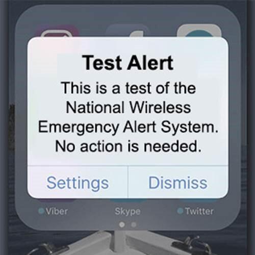
FEMA, partnering with the Federal Communication Commission, will conduct a national test of the Emergency Alert System and Wireless Emergency Alert with radio, TV, cable stations, and wireless carriers at 2:20 PM Eastern Time on August 11, 2021. The EAS test is expected to last around one minute and will confirm the ability of the system to deliver a national EAS message.

alert - info

If you are not receiving WEAs here are some tips to troubleshoot your mobile device:

  1. Check the settings on your mobile device and review your user manual (you may be able to find this online too).
    • Older phones may not be WEA capable, and some cell phone models require you to enable WEAs.
    • Some mobile service providers call these messages “Government Alerts,” or “Emergency Alert Messages.”
  2. Check with your wireless provider to see if they can resolve the issue.

To provide comments or concerns about WEAs sent in your area contact local officials directly.


Event Details

FEMA, in coordination with the Federal Communications Commission, will conduct a nationwide test of the Emergency Alert System (EAS) and Wireless Emergency Alerts (WEA) this summer.

The national test will consist of two portions, testing WEA and EAS capabilities. Both tests will begin at 2:20 p.m. ET on Wednesday, Aug. 11.

The EAS national test is very similar to regular monthly tests typically originated by state authorities. During the test, radios and televisions across the country may interrupt normal programming to play the EAS test message. The message may be delivered in English or Spanish. 

The WEA test will be directed only to consumer cell phones where the subscriber has opted-in to receive test messages, which will be in either English or Spanish, depending on the device’s language settings. Most mobile phones will not display the test message. In contrast, consumers will automatically receive real emergency alerts on compatible phones (even if they do not receive the test message).  Instructions for how to opt-in to receive the test message on mobile devices can be found here.

Additional Information

Frequently Asked Questions (FAQs)

FEMA, FCC Conducting System Tests of Public Alert and Warning Infrastructures

FEMA and FCC Plan Nationwide Emergency Alert Test for Aug. 11 Test Messages Will be Sent to TVs and Radios Along with Select Cell Phones That Have Opted-in to Receive Test Messages Press Release

Monday, May 10, 2021

What's Your Food Safety Plan for Hurricane Season?


USDA PRESS RELEASE (05-10-2021)
FOOD SAFETY AND INSPECTION SERVICE

We've seen the power a hurricane can carry, and the devastation it leaves behind. Prolonged power outages and flood damage are two of the biggest risks to your food. Fortunately, a plan can help keep you and your family safe from foodborne illness.

DAY SPONSOR

Carrion Tree Service is underwriting Macon Media for today. they are a fully licensed and insured tree service, specializing in dangerous tree removal, view clearing, pruning, and crane services with a 24 Hour emergency response.

Their phone number is 371-4718.

They can handle all your tree removal needs in good or bad weather.

During Hurricane Preparedness Week, develop your action plan before a storm hits.

• Buy ice packs and coolers days before the hurricane arrives in case there is a prolonged power outage. 
• Pour water into containers and freeze it to make ice.
• Use an appliance thermometer to determine the safety of your perishable foods. Meat, poultry, fish and egg products must be kept at 40 F or below and frozen food at 0 F or below.
• For meats, check the canned goods aisle of your local grocery story for canned meats. These are fully cooked and unopened canned meats don’t require refrigeration.

Illness-causing bacteria grow in temperatures between 40 F and 140 F. We call these temperatures the “Danger Zone” for food. Bacteria that develop at these temperatures generally do not alter the taste, appearance, or smell of the food but can make you sick. During a power outage, a refrigerator will keep food safe for up to four hours and a full freezer will hold temperatures for 48 hours or 24 hours if half full.

Caution—never taste food to determine its safety. When in doubt, throw it out! Throw out any food that has been in contact with flood water. This includes any canned foods with signs of damage such as holes, leakages, and punctures. Place foods on higher shelves to lessen the chance of them being contaminated by flood water.

Learn more food safety tips for storms or other emergencies.

For more information about food safety and for a free food thermometer, contact the USDA’s Meat and Poultry Hotline at 1-888-MPHotline (1-888-674-6854) to talk to a food safety expert or chat live at ask.usda.gov from 10 a.m. to 6 p.m. Eastern Time, Monday through Friday.

PDF Copy of food safety tips 


CROWDFUNDING OR DAY SPONSORSHIP OPPORTUNITIES


If you receive value from what Macon Media provides to the community, please consider becoming a supporter and contribute at least a dollar a month. Those who support Macon Media with at least a dollar a month receive early access to video of some events and meetings before they are made public on the website. Videos and news involving public safety are not subject to early access.


Become a Patron!


Or, if you prefer Pay Pal, try PayPal.me/MaconMedia


Published at 11:00am on Monday, May 10, 2021


Tuesday, March 9, 2021

Think before burning yard debris during spring wildfire season

Photo taken at the Camp Branch Fire on 11-28-2016 by Bobby Coggins 

  As you are all probably aware, we are in the spring fire season, where dry conditions and low humidity can mix with wind gusts to cause fires to get out of control in a hurry. Please be aware of the forecasts and check with your local ranger or obtain a burning permit online before burning debris or yard waste. [LINK]

Here is a press release from the NC Forest Service reminding us of the dangers of burning when conditions are favorable for fire spread.


PRESS RELEASE

NC FOREST SERVICE

RALEIGH - In North Carolina, March through May is historically recognised as spring wildfire season, a period when conditions are more favorable for wildfire. As residents begin working in their yards, the N.C. Forest Service urges them to think before burning yard debris.

“Every year, almost 40% of wildfires in North Carolina are the result of careless debris burning,” said Agriculture Commissioner Steve Troxler. “To protect ourselves and our forestland from wildfire, we have to be responsible and vigilant. Check the weather. Make sure you’re prepared to burn before you do. Never leave a debris fire unattended, and always have a water source and phone nearby in case you need them.”

There are many factors to consider before burning yard debris. The N.C. Forest Service encourages residents to contact their local county forest ranger for technical advice and options to help ensure the safety of people, property and the forest. To find contact information for your local NCFS county ranger, visit www.ncforestservice.gov/contacts.

The NC Forest Service offers the following tips to protect property and prevent wildfires:

  • Consider alternatives to burning. Some types of debris, such as leaves, grass and stubble, may be of more value if they are not burned, but used for compost or mulch instead.
  • Check local burning laws. Some communities allow burning only during specified hours. Others forbid it entirely.
  • Make sure you have a valid permit. You can obtain a burn permit at any open authorized permitting agent or online at www.ncforestservice.gov/burnpermit.
  • Local fire officials can recommend a safe way to burn debris. Don’t pile vegetation on the ground. Instead, place it in a cleared area and contain it in a screened receptacle away from overhead branches and wires. Keep your pile small, not tall.
  • Stay informed about the weather and possible weather changes. Postpone outdoor burning during high winds or gusts, or periods of low relative humidity. Even if you have a valid permit, stop burning if strong winds develop.
  • Be sure you are fully prepared before burning. To control the fire, you will need a hose, bucket, steel rake, and a shovel for tossing dirt on the fire. Keep a phone nearby, too.
  • Never use kerosene, gasoline, diesel fuel or other flammable liquids to speed up debris burning.
  • Stay with your fire until it is completely out.

To learn more about fire safety and preventing wildfires and property damage or loss, visit www.ncforestservice.gov. To learn more about actions you can take to prepare your home and property for wildfire, visit www.resistwildfirenc.org.


CROWDFUNDING OR DAY SPONSORSHIP OPPORTUNITIES


If you receive value from what Macon Media provides to the community, please consider becoming a supporter and contribute at least a dollar a month. Those who support Macon Media with at least a dollar a month receive early access to video of some events and meetings before they are made public on the website. Videos and news involving public safety are not subject to early access.


Become a Patron!


Or, if you prefer Pay Pal, try PayPal.me/MaconMedia


Published at 11:00am on Tuesday, March 09, 2021


Severe Weather Preparedness Week 2021

Photo taken on June 15, 2017 by Bobby Coggins. [LINK]

We are approaching severe weather season in Macon County, and the National Weather Service has issued a Public Information Statement with some helpful advice on ways members of the community can receive information about impending severe weather events. There will also be a statewide tornado drill in North Carolina tomorrow at 9:30am. An alert will be sent out via all methods posted below. Macon Media will also be participating in the event and will relay the alert when it is posted. You are encouraged to have multiple methods of receiving alerts from the National Weather Service to increase your chances of receiving information in a timely manner that may save your life and the lives of those around you.


Weather Sponsor


Adams Products, a Division of Oldcastle is underwriting the daily weather briefing & public safety updates for the month.

Open 7:30 AM to 4:00 PM, M-F, located at 895 Hickory Knoll Road, Franklin, NC. Visit our Facebook page at: https://www.facebook.com/Adams.Oldcastle.Franklin.NC

All your masonry needs are available. Our phone number is 828.524.8545, the public is welcome, we’ll help you with your next project.


Public Information Statement
National Weather Service Greenville-Spartanburg SC
744 AM EST Tue Mar 9 2021

...SEVERE WEATHER PREPAREDNESS WEEK IN NORTH CAROLINA IS MARCH 7TH THROUGH MARCH 13TH THIS YEAR...

Today's Topics: Ways to receive severe weather alerts, and information about tomorrow's Statewide Tornado Drill

One of the keys to staying safe during the severe weather season is making sure that you have a way to receive lifesaving severe weather watches and warnings. There are many methods and tools, some of which are available with no cost or fees, that you can use to receive these important lifesaving alerts no matter where you are - at home, at school, or at work. Here is a partial list of these methods and tools.

* NOAA Weather Radio: NWR is a nationwide network of radio stations broadcasting continuous weather information from the nearest National Weather Service office. Specially built receivers, which can be purchased at most electronics and large retail stores for less than $40, receive the NWR broadcast 24 hours a day, 7 days a week, and sound an audible alert when official watches and warnings are issued for your area. Think of these radios as a "smoke detector" for severe weather alerts.

* Wireless Emergency Alerts (WEA): With WEA, emergency alerts can be sent to your cell phone or mobile device when you may be in harm's way, without the need to download an app or subscribe to a service. In addition to other alert types such as AMBER Alerts, this free service will transmit extreme weather warnings to your cell phone, such as Tornado Warnings and Flash Flood Warnings for considerable or catastrophic flooding. The alerts will look like a text message, and will typically show the type and time of the alert, any action you should take. WEA messages include a special tone and vibration. If you receive a WEA message, you should follow any action advised by the emergency message. Seek more details from your favorite TV or radio station, NOAA Weather Radio, news website, desktop application, mobile application, or other trusted source of information.

* Cell phone apps: There are many great cell phone apps that provide real-time NWS warnings and alerts, some of which are free to download and use, and others that may charge a small fee. A simple search of your app provider will reveal many of these apps.

* Emergency Alert System (EAS) and your favorite TV and radio stations: EAS is the message dissemination pathway that sends warnings via broadcast, cable, satellite, and wireline services. EAS may be used by state and local authorities, including the National Weather Service, in cooperation with the broadcast community, to deliver important emergency information such as severe weather information, AMBER alerts, and local incident information targeted to specific areas. In short, when severe weather strikes, it's a good idea to tune to your favorite local TV or radio station or web site for detailed information about the severe weather threat.

In addition to the aforementioned alerting system, many communities also offer free emergency alert notifications through their own systems, such as reverse 911 phone systems. Be sure to check with your local emergency management agency to learn what is available in your area.

Tomorrow (Wednesday, March 10) at 9:30 AM, the National Weather Service in cooperation with local broadcasters will conduct a statewide tornado drill. The alarm test, which will come in the form of a Required Monthly Test, will activate the State Emergency Alert System and be carried by local radio broadcasters. Every school, business, and residence is encouraged to participate in this drill. It's really easy. At 9:30 AM on Wednesday, take a few moments to practice your severe weather safety plan, and seek shelter for a few minutes as if a tornado was headed your way. To help you prepare for this drill, be sure to visit the National Weather Service's severe weather preparedness website at http://www.weather.gov/gsp/swaw_2021 where you can learn more about seeking safe shelter when severe weather strikes. In addition, throughout the day Wednesday, the NWS will feature NOAA Weather Radio messages and social media posts that highlight severe weather safety tips.

Be sure to take some time this week to learn more about severe weather safety. Learning and practicing severe weather safety when the weather is good will allow you to react more quickly when the weather turns bad. You can learn more about severe weather safety by visiting the North Carolina Department of Public Safety preparedness website at readync.org. This web page features an abundance of information that will help you plan and prepare for the severe weather season. Once again, that's readync.org.

CROWDFUNDING OR DAY SPONSORSHIP OPPORTUNITIES


If you receive value from what Macon Media provides to the community, please consider becoming a supporter and contribute at least a dollar a month. Those who support Macon Media with at least a dollar a month receive early access to video of some events and meetings before they are made public on the website. Videos and news involving public safety are not subject to early access.


Become a Patron!


Or, if you prefer Pay Pal, try PayPal.me/MaconMedia


Published at 10:10am on Tuesday, March 09, 2021


Wednesday, February 17, 2021

Governor issues State of Emergency, orders transportation waivers to speed help


PRESS RELEASE
GOVERNOR COOPER
RALEIGH, NC
FEB 17, 2021


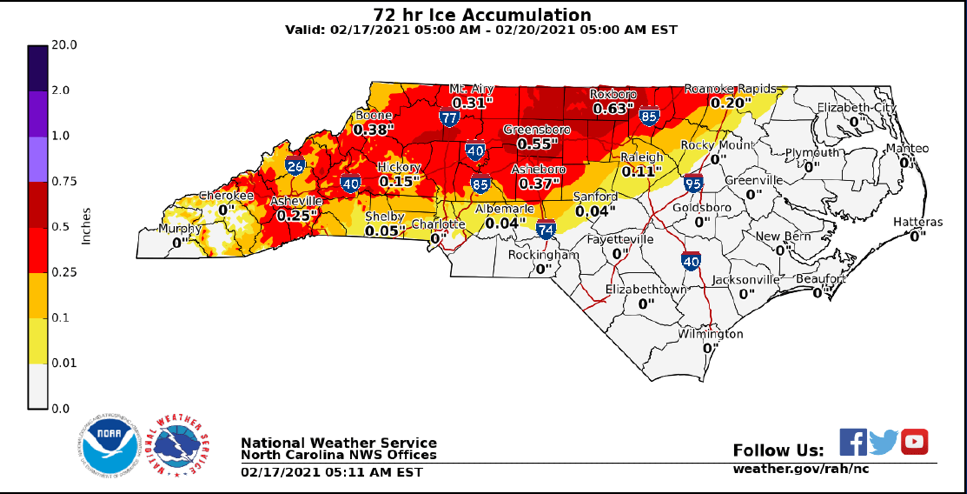
North Carolina residents should prepare today for the strong possibility of power outages due to an incoming winter storm that is forecast to arrive tonight. This storm will bring significant icing that’s likely to result in many fallen trees and power lines.

“This forecast for icy weather is a real threat for widespread power outages,” said Governor Roy Cooper. "People need to be ready to stay home and be prepared to lose power for a while, especially in the northern, western and Piedmont counties."

These areas especially north and west could see between one-quarter and one-half inch of ice or more. Power outages are common with as little as a quarter-inch of icing on trees and power lines.

The Governor will issue an Executive Order today in advance of the inclement weather, declaring a state of emergency and allowing for transportation waivers permitting utility companies to bring repair crews from out of state and get faster access to communities who have lost power. The Governor also authorized the activation of 40 National Guard personnel to support fallen tree and debris removal.

State transportation officials advise that unnecessary travel should be avoided late tonight and Thursday across much of western and central North Carolina due to ice on roads and falling trees. Downed trees and power lines can be very difficult to see at night.

State transportation workers have started brining major highways, bridges and overpasses in some areas. As of 11 a.m., crews had placed nearly 30,000 gallons of brine on roads in the Triangle, Piedmont Triad, Charlotte area and mountains. Crews are loading trucks with salt and sand so deicing operations can start during the storm’s aftermath. Transportation crews will be working through the night to clear roads, as necessary.

North Carolina Emergency Management is monitoring the storm’s progress and is prepared to assist counties with any storm-related needs.

Emergency managers offer these tips for staying safe during this ice storm:

• Be prepared for power outages by making sure you have several days supply of food, medicine and water 
• Make sure your cell phone and other electronic or medical devices are fully charged, along with any backup batteries 
• Don’t park your car under trees or power lines 
• Use battery powered lights, instead of candles, if your power goes out 
• Avoid running generators or grills in your home or garage if your power goes out. Deadly carbon monoxide fumes can accumulate while using generators or grills indoors. 


CROWDFUNDING OR DAY SPONSORSHIP OPPORTUNITIES


If you receive value from what Macon Media provides to the community, please consider becoming a supporter and contribute at least a dollar a month. Those who support Macon Media with at least a dollar a month receive early access to video of some events and meetings before they are made public on the website. Videos and news involving public safety are not subject to early access.


Become a Patron!


Or, if you prefer Pay Pal, try PayPal.me/MaconMedia


Published at 4:44pm on Wednesday, February 17, 2021


Duke Energy projects nearly 1 million power outages in Carolinas due to approaching winter storm


**update** The Governor has issued a State of Emergency [LINK]

There is a potential for a major winter weather event in part of Macon County over the next 24 hours, especially at the higher elevations and on the Highlands Plateau. Here are some basic phone numbers and safety tips to keep in mind, then a press release from Duke Energy follows that. Be safe, and be kind and if your area does get hit, please remember to check on your neighbors.

SAFETY TIPS AND HELPFUL NON-EMERGENCY NUMBERS

Remember to NEVER touch downed power lines.

Here is a Reminder of Helpful Phone Numbers:

Non-emergency reports: 369-9116
Highway Patrol Dispatch: 1-800-445-1772
Franklin Police: 524-2864
Highlands Police: 526-9431
Animal Control: 349-2106
Sheriff's Office: 349-2104

HOW TO REPORT AN ELECTRICAL OUTAGE

Duke Energy

Call 800.769.3766 or in Spanish 866.4.Apagón (866.427.2466).
If you see a fallen power line or safety hazard, call Duke Energy at 800.Power.On (800.769.3766) or in Spanish 866.4.Apagón (866.427.2466) or contact your local emergency services immediately. Do not touch a power line or anything in contact with it and keep others away until help arrives.

Haywood EMC

To report or inquire about power outages, call 1-800-951-6088


PRESS RELEASE
DUKE ENERGY
CHARLOTTE, NC
February 17, 2021


•Customers in storm’s path should prepare for multi-day power outages.
•Thousands of workers ready to begin power restoration after storm passes, including 5,400 line technicians and vegetation specialists.

CHARLOTTE, N.C. – Duke Energy today projected that the hazardous wintry precipitation and high-winds from the approaching winter storm could cause nearly 1 million power outages – some lasting several days – beginning Thursday in North Carolina and South Carolina, based on the storm’s current forecasted track.

Duke Energy has thousands of employees supporting the company’s response, including 5,400 line technicians and vegetation workers. More than 1,300 of those workers are from the company’s Midwest and Florida service areas and from other companies providing assistance.

Ice buildup causing trees and branches to fall on power lines is usually the culprit for power outages during an ice storm. Ice buildup of a quarter-inch or more is often the threshold amount that causes trees and branches to fall.

The storm comes on the heels of last weekend’s winter storm which caused significant outages in the northern part of North Carolina, as well as the Triad and Triangle areas of the state.

Duke Energy meteorologists continue to monitor weather conditions and the company is making plans accordingly. Line technicians, service crews and other personnel throughout Duke Energy's service area are prepared to respond as outages and emergencies occur.

As part of the company’s preparation, workers are checking equipment, supplies and inventories to ensure workers have adequate materials to make repairs and restore power outages.

Duke Energy has completed aerial inspections of its transmission lines in the communities expected to be hit hardest, and found no immediate threats.

The company has an adequate supply of electricity to meet energy demands; outages related to power generation are not expected.

Weather and travel conditions might be hazardous and challenging following the storm’s impact, and could delay Duke Energy workers’ ability to access areas to fully assess storm damage and restore electric service.

Following the storm, crews will first assess the extent of damage – which can sometimes take 24 hours or more – to determine which crews, equipment and supplies are needed.

Damage assessments occur while other workers simultaneously restore power in some areas. Estimated times of restoration will be provided when damage assessments are completed.

The company will provide regular updates to its customers and communities via email, text messages, outbound phone calls, social media and its website.

Customers should prepare

Duke Energy urges customers to have a plan in place now, in the event they experience an extended power outage.

With temperatures forecasted to be below freezing Friday and Saturday in many areas of both states, customers should consider alternative locations for family members who are elderly or who have special medical needs, if outages are extended.

When checking on neighbors and friends, be sure to follow social distancing recommendations, local orders and restrictions, and other CDC recommendations to protect yourself and others.

Tips to help you and your family stay safe

• Create (or update) an emergency supply kit to save valuable time later. The kit should include everything an individual or family would need for at least two weeks, especially medicines, water, non-perishable foods, blankets, travel bags and other supplies that might be hard to find after a storm strikes. Your emergency kit should also include items that can help protect you and others from COVID-19, such as hand sanitizer, bar or liquid soap, and face coverings aligned with CDC guidance.

• Keep a portable radio or TV, or NOAA weather radio on hand to monitor weather forecasts and important information from state and local officials.

• Charge cellphones, computers and other electronic devices in advance of storms to stay connected to important safety and response information. Consider purchasing portable chargers and make sure they are fully charged as well.

• Stay away from power lines that have fallen or are sagging. Consider all lines energized as well as trees or limbs in contact with lines. Please report downed power lines to Duke Energy.

• If a power line falls across a car that you're in, stay in the car. If you MUST get out of the car due to a fire or other immediate life-threatening situation, do your best to jump clear of the car and land on both feet. Be sure that no part of your body is touching the car when your feet touch the ground.

• If you use a generator due to a power outage, follow the manufacturer's instructions to ensure safe and proper operation. Operate your generator outside. Never operate it inside a building or garage.

Reporting outages and receiving updates

• Before a storm hits, customers can sign up to receive outage alerts, and ensure contact information is current and communication preferences specified. Throughout the storm, the company will also provide updates to customers via email, phone, text and the website.

Customers who experience a power outage can report it the following ways:

Visit duke-energy.com on a desktop computer or mobile device.

Use the Duke Energy mobile app – download the Duke Energy App from a smartphone via Apple Store or Google Play.

Text OUT to 57801 (standard text and data charges may apply).

Call Duke Energy’s automated outage-reporting system:
Duke Energy Carolinas: 1-800-POWERON (1-800-769-3766)
Duke Energy Progress: 800.419.6356

Lake levels

Heavy rainfall will result in higher lake and river levels across the Catawba River basin. Duke Energy is moving water through the river system, including moving water through our hydro generating units and flood gates.

Lake residents should prepare for possible flooding conditions and closely monitor lake levels. High water conditions can create navigational hazards.

The company urges people living along lakes and rivers, and in flood-prone areas, to use caution, follow directions from emergency management officials, pay close attention to changing weather and stream-flow conditions, and stay informed.

We are posting real-time updates on:

duke-energy.com/lakes

Duke Energy’s lake services phone line: 800.829.5253

Duke Energy’s free Lake View app (downloadable from your cell phone app store)
Duke Energy also will provide updates on its social media channels to keep customers informed if significant outages occur:

Duke Energy on Twitter: www.twitter.com/DukeEnergy

Duke Energy on Facebook: www.facebook.com/DukeEnergy

CROWDFUNDING OR DAY SPONSORSHIP OPPORTUNITIES


If you receive value from what Macon Media provides to the community, please consider becoming a supporter and contribute at least a dollar a month. Those who support Macon Media with at least a dollar a month receive early access to video of some events and meetings before they are made public on the website. Videos and news involving public safety are not subject to early access.


Become a Patron!


Or, if you prefer Pay Pal, try PayPal.me/MaconMedia


Published at 2:30pm on Wednesday, February 17, 2021


Friday, August 21, 2020

This Week at NCDOT: Fayetteville Outer Loop, Preparedness Month, 2020 Census


RALEIGH – The following are highlights from this week at the N.C. Department of Transportation. The stories below are also featured in NCDOT Now, the department's weekly newscast.

NCDOT Now Video


New Section of Fayetteville Outer Loop Complete

This week, drivers began using a new, 2.7-mile segment of the Fayetteville Outer Loop, which is Interstate 295. The highway is improving regional access to Fort Bragg, I-95 and the Fayetteville area. Over half of the 39-mile loop has been built and the rest is expected to be completed by 2026.

N.C. Preparedness Month

North Carolina has already felt the impacts from Hurricane Isaias, but we’re still in the middle of hurricane season and it is not too late to prepare for other tropical storms. Gov. Roy Cooper proclaimed August as North Carolina Preparedness Month and encouraged people to review their emergency plans and update their emergency supplies.

Hurricane season lasts through the end of November, so it is vital for communities, families and businesses to prepare for hurricanes, tornadoes and other disasters. This year, it’s also important to consider COVID-19 as part of your plan. For more information go to readync.org.

Participate in the 2020 Census

NCDOT is partnering with the state Department of Administration to get the word out about the 2020 Census.

Filling out a Census survey takes less than 10 minutes but can help shape your future for the next 10 years. Census data ensures communities get money for critical needs like housing, schools, roads and health care.

People can fill out a Census survey online, by phone or mail without ever leaving home or talking to anyone in person. Federal law requires all information collected be kept confidential. To take the Census online, go to my2020census.gov.

For more information about NCDOT Now, contact the NCDOT Communications Office at (919) 707-2660. Additional news stories from throughout the week can be found on NCDOT.gov.


CROWDFUNDING OR DAY SPONSORSHIP OPPORTUNITIES


If you receive value from what Macon Media provides to the community, please consider becoming a supporter and contribute at least a dollar a month. Those who support Macon Media with at least a dollar a month receive early access to video of some events and meetings before they are made public on the website. Videos and news involving public safety are not subject to early access.


Become a Patron!

Or, if you prefer Pay Pal, try PayPal.me/MaconMedia


Published at 10:00am on Firday, August 21, 2020


Sunday, March 15, 2020

Walmart Adjusts Business Hours During Corona Virus (COVID-19) Outbreak


Walmart Corporate has reduced the hours their stores are open for business to 6am to 11pm so the stores can be properly cleaned and stocked. A copy of the announcement is posted below.


March 14, 2020
By Dacona Smith,
Executive Vice President and Chief Operating Officer,
Walmart U.S.


I could not be prouder of our associates and what they continue to accomplish for our customers. I don’t think any of us have been through an experience like this, and we continue to be amazed at what our people, whether in the stores or in the supply chain, are doing to make sure customers have what they need.

To better support our associates and serve our customers, we will adjust our operating hours beginning Sunday, March 15. Walmart stores and Neighborhood Markets will be open from 6 a.m. to 11 p.m. until further notice. This will help ensure associates are able to stock the products our customers are looking for and to perform cleaning and sanitizing. Stores currently operating under more reduced hours (for example they regularly close at 10 p.m. or open at 7 a.m.) will keep their current hours of operation.

As we make this change, associates will continue to work the hours and shifts they are scheduled, and our supply chain and trucking fleet will continue to move products and deliver to stores on their regular schedules. As a reminder, we have a temporary COVID-19 emergency leave policy to support associates at this unprecedented time.

To our associates, thank you for your incredible work during this time. I know it hasn’t always been easy, but your entire Walmart family is so proud of what you are doing and the important difference you are making, both for your neighbors and for your country.

Published at 4:02am on Sunday, March 15, 2020


Saturday, August 31, 2019

USDA Offers Food Safety Tips for Areas Affected by Hurricane Dorian


USDA Office of Communications
Press Release

WASHINGTON, Aug. 31, 2019 — The U.S. Department of Agriculture’s (USDA) Food Safety and Inspection Service (FSIS) is issuing food safety recommendations for those who may be impacted by Hurricane Dorian.

The National Hurricane Center reports that life threatening storm surge and devastating hurricane force winds are still possible along portions of the Florida east coast by the early to middle part of next week, but since Dorian is forecast to slow down and turn northward near the coast, is too soon to determine where or where the highest surge or winds will occur. Residents should have their hurricane plan in place, know if they are in a hurricane evacuation zone, and listen to advise given by local emergency officials. The risk of strong winds and life-threatening storm surge is increasing along the coasts of Georgia and South Carolina during the middle of next week. Residents on those areas should continue to monitor the progress of hurricane Dorian.

Hurricanes present the possibility of power outages and flooding that can compromise the safety of stored food. Residents in the path of this hurricane should pay close attention to the forecast. FSIS recommends that consumers take the following steps to reduce food waste and the risk of foodborne illness during this and other severe weather events.

Steps to follow in advance of losing power:

•Keep appliance thermometers in both the refrigerator and the freezer to ensure temperatures remain food safe during a power outage. Safe temperatures are 40°F or lower in the refrigerator, 0°F or lower in the freezer.
•Freeze water in one-quart plastic storage bags or small containers prior to a hurricane. These containers are small enough to fit around the food in the refrigerator and freezer to help keep food cold. Remember, water expands when it freezes, so don’t overfill the containers.
•Freeze refrigerated items, such as leftovers, milk and fresh meat and poultry that you may not need immediately—this helps keep them at a safe temperature longer.
•Know where you can get dry ice or block ice.
•Have coolers on hand to keep refrigerator food cold if the power will be out for more than four hours.
•Group foods together in the freezer—this ‘igloo’ effect helps the food stay cold longer.
•Keep a few days’ worth of ready-to-eat foods that do not require cooking or cooling.

Steps to follow if the power goes out:

•Keep the refrigerator and freezer doors closed as much as possible. A refrigerator will keep food cold for about four hours if the door is kept closed. A full freezer will hold its temperature for about 48 hours (24 hours if half-full).
•Place meat and poultry to one side of the freezer or on a tray to prevent cross contamination of thawing juices.
•Use dry or block ice to keep the refrigerator as cold as possible during an extended power outage. Fifty pounds of dry ice should keep a fully-stocked 18-cubic-feet freezer cold for two days.

Steps to follow after a weather emergency:

•Check the temperature inside of your refrigerator and freezer. Discard any perishable food (such as meat, poultry, seafood, eggs or leftovers) that has been above 40°F for two hours or more.
•Check each item separately. Throw out any food that has an unusual odor, color or texture or feels warm to the touch.
•Check frozen food for ice crystals. The food in your freezer that partially or completely thawed may be safely refrozen if it still contains ice crystals or is 40°F or below.
•Never taste a food to decide if it’s safe.
•When in doubt, throw it out.

Food safety after a flood:

•Do not eat any food that may have come into contact with flood water—this would include raw fruits and vegetables, cartons of milk or eggs.


•Discard any food that is not in a waterproof container if there is any chance that it has come into contact with flood water. Food containers that are not waterproof include those packaged in plastic wrap or cardboard, or those with screw‐caps, snap lids, pull tops and crimped caps. Flood waters can enter into any of these containers and contaminate the food inside. Also, discard cardboard juice/milk/baby formula boxes and home-canned foods if they have come in contact with flood water, because they cannot be effectively cleaned 
and sanitized.

•Inspect canned foods and discard any food in damaged cans. Can damage is shown by swelling, leakage, punctures, holes, fractures, extensive deep rusting or crushing/denting severe enough to prevent normal stacking or opening with a manual, wheel‐type can opener. 

FSIS will provide relevant food safety information as the storm progresses on Twitter @USDAFoodSafety and Facebook.

FSIS’ YouTube video “Food Safety During Power Outages” has instructions for keeping frozen and refrigerated food safe.


The publication “A Consumer’s Guide to Food Safety: Severe Storms and Hurricanes” can be downloaded and printed for reference during a power outage. LINK

If you have questions about food safety during severe weather, or any other food safety topics, call the USDA Meat & Poultry Hotline at 1-888MPHotline or chat live with a food safety specialist at AskKaren.gov. These services are available in English and Spanish from 10 a.m. to 6 p.m. Eastern Time, Monday through Friday. Answers to frequently asked question can also be found 24/7 at AskKaren.gov.

Published at 1:27pm on Saturday, August 31, 2019


Wednesday, December 5, 2018

Daily Weather Briefing for Wednesday, December 5, 2018


Outlook

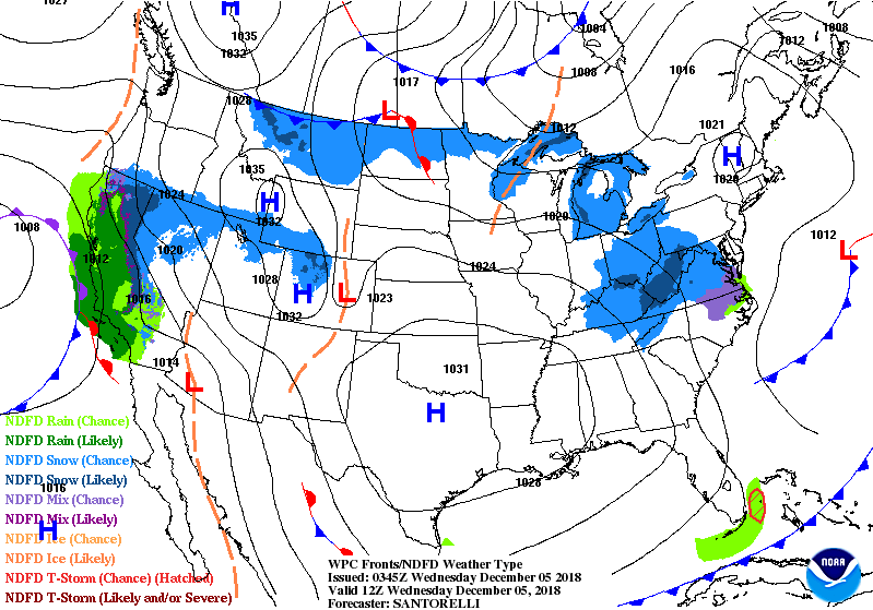
Dry Canadian high pressure will remain across the region and hold temperatures below normal through the end of the week. A moist and cold wintry storm will affect the region over the weekend. As of 2 am Wednesday, it is still unclear how much of this will fall as rain or snow in Macon County. The transition line between all snow and all rain for this event will be either in Macon County or just to our east. Those who end up on the west side of the transition line will see all rain or mostly all rain.

Stay tuned to local weather sources to keep up to date with changes in the forecast. Official information on weather advisories, watches, and warnings from the National Weather Service is available online at is.gd/MACONWARN

If it does snow, sleet, ice or freezing rain does fall in our area, please be mindful of safety, and consider leaving early so you can drive at a safe speed. You might also consider canceling travel plans and stay off the roads so the NCDOT can better clear the roads. This will also reduce the need for emergency personnel so they can respond to emergency situations instead of your fender bender or serious accident.


THREE DAY GFS FORECAST
This animated image shows a forecast of precipitation, air pressure and thickness level (cold-air damming) for three days in six-hour increments.
Green, Yellow, and Red indicate rain. Orange and Purple Indicate Freezing Rain or other freezing precipitation. Blue indicates snow.


WEATHER SPONSOR


Adams Products, a Division of Oldcastle is underwriting the daily weather briefing & public safety updates for the month.

Open 7:30 AM to 4:00 PM, M-F, located at 895 Hickory Knoll Road, Franklin, NC. Visit our Facebook page at:
https://www.facebook.com/Adams.Oldcastle.Franklin.NC/

All your masonry needs are available. Our phone number is 828.524.8545, the public is welcome, we’ll help you with your with your next project.


Weather Hazards

Hazardous weather is not anticipated today.

A strong coastal low-pressure system will likely bring periods of moderate to heavy rain and wintry precipitation to the area this weekend. Snow and ice accumulations are most likely across the region. Now is the time to make preparations for potential power outages. You should always be prepared to be without electrical service for 72 hours.

FEMA has a good guide to preparing for ice storms and tips also apply to snow storms. [LINK]

Stay tuned to local weather sources to keep up to date with changes in the forecast. Official information on weather advisories, watches, and warnings from the National Weather Service is available online at is.gd/MACONWARN


WEATHER FORECAST MAPS

Forecast maps for 7 am, 1 pm, and 7 pm.
[click on any image in this article to enlarge]


FRANKLIN AREA FORECAST

Today

Mostly sunny, with a high near the upper 30s. Winds out of the northwest 5 to 10 mph.

Tonight

Mostly clear, with a low around 20. Winds out of the northwest around 5 mph becoming calm in the evening.

Thursday

Mostly sunny, with a high near 45. Calm wind rising to come out of the west around 5 mph in the afternoon.

Thursday Night

Mostly cloudy, with a low near the upper 20s. Calm wind rising to come out of the northwest around 5 mph after midnight.

Friday

Partly sunny, with a high near 50.

Friday Night

A 30 percent chance of rain after 2am. Mostly cloudy, with a low around freezing.


OTTO AREA FORECAST

Today

Mostly sunny, with a high in the upper 30s. Winds out of the northwest 5 to 10 mph.

Tonight

Mostly clear, with a low in the lower 20s. Winds chill values will be in the upper teens at times. Winds out of the north 5 to 10 mph.

Thursday

Mostly sunny, with a high near 45. Calm wind rising to come out of the southwest around 5 mph in the afternoon.

Thursday Night

Mostly cloudy, with a low around 30. Winds out of the northwest 3 to 5 mph.

Friday

Partly sunny, with a high near 50.

Friday Night

A 30 percent chance of rain, mainly after 1am. Mostly cloudy, with a low around 35.


HIGHLANDS PLATEAU FORECAST

Today

Mostly sunny, with a high near 30. Wind chill values in the lower 20s. Winds out of the northwest wind 15 to 20 mph, with gusts as high as 30 mph.

Tonight

Mostly clear, with a low around 20. Wind chill values in the teens and down into the single digits at times. Winds out of the northwest 10 to 15 mph, with gusts as high as 25 mph. Winds are expected to gradually diminish to 5 to 10 mph by daybreak.

Thursday

Mostly sunny, with a high near 40. Winds out of the southwest 5 to 10 mph.

Thursday Night

Mostly cloudy, with a low In the upper 20s. Winds out of the northwest 5 to 10 mph.

Friday

Partly sunny, with a high in the lower 40s. Locations with a northern exposure may not leave the mid-to-upper 30s.

Friday Night

A 30 percent chance of rain after 1am. Mostly cloudy, with a low around freezing.


NANTAHALA AREA FORECAST

Today

Partly sunny, with a high near 30. Wind chill values will make it feel like it is in the the low-to-mid 20s at times. Winds out of the northwest 10 to 15 mph, with gusts as high as 25 mph.

Tonight

Mostly clear, with a low around 20. Winds out of the northwest 5 to 10 mph.

Thursday

Mostly sunny, with a high near 40. Light and variable winds rising to come out of the west around 5 to 10 mph in the morning.

Thursday Night

Mostly cloudy, with a low near the upper 20s. Winds out of the northwest around 5 mph.

Friday

Partly sunny, with a high near 45.

Friday Night

A 30 percent chance of rain, mainly after 1am. Mostly cloudy, with a low around freezing.


Macon County Almanac for December 5, 2018

Highest Temperature 72°F at the Coweeta Experimental Station in 1956
Lowest Temperature 7°F in Highlands in 1985
Greatest Rainfall 3.74 inches in Highlands in 1941
Greatest Snowfall 2.0 inches in Highlands in 1971


CROWDFUNDING OR DAY SPONSORSHIP OPPORTUNITIES


If you receive value from what Macon Media provides to the community, please consider becoming a supporter and contribute at least a dollar a month. Those who support Macon Media with at least a dollar a month receive early access to video of some events and meetings before they are made public on the website. Videos and news involving public safety are not subject to early access.


Become a Patron!

If you have a business or event you are interested in sponsorship opportunities or underwriting coverage, send an email to editor@MaconMedia.com for more information. Serious inquiries only. Macon Media rewards early sponsors/underwriters with lifetime guaranteed low rates while newer sponsors/underwriters pay higher rates based on the date they first support Macon Media.

Thank You to the people who have been sending in donations and those businesses who are underwriting coverage of news and events. You have kept Macon Media online.

Published at 2:30 am on December 5, 2018


Friday, April 27, 2018

Today Marks the 7th Anniversary of the 2011 Super Outbreak
Preparedness Information Included


The Super Outbreak of Tornadoes that occurred from April 25-28, 2011 cost at least 360 people their lives, injured over 3,000 people left thousands without their homes and businesses. It caused the equivalent of over $12 billion in damage in 2018 dollars. Below is a video from James Spann recounting that day in Alabama, then a couple of videos from people who filmed various tornadoes that day, then a list of resources you can use to prepare yourself for severe weather.


WEATHER SPONSOR


Adams Products, a Division of Oldcastle is underwriting the daily weather briefing & public safety updates for the month.

Open 7:30 AM to 4:00 PM, M-F, located at 895 Hickory Knoll Road, Franklin, NC. Visit our Facebook page at:
https://www.facebook.com/Adams.Oldcastle.Franklin.NC/

All your masonry needs are available. Our phone number is 828.524.8545, the public is welcome, we’ll help with your with your next project.


Andy Gabrielson, the storm chaser who shot the above video, was later killed while returning from a chase by a drunk driver on February 4, 2012. EarthSky has a tribute to him on their website. [LINK]


This video is from the EF4 tornado that went through Tuscaloosa, AL on 4/27/11. It was taken from the University Mall parking lot.


The storm that hit Tuscaloosa eventually made it to Macon County [see the above radar image of the Tornado Warning] just before midnight and a tornado caused damage in Saly Mountain, NC. [LINK]

A more comprehensive write up on the outbreak by the local weather service office is also online. [LINK]


With that in mind, although our mountains do protect us from most tornadoes, that protection is not 100% effective so it would be prudent to prepare for them just in case.

Here is some general information on severe weather to assist you in becoming more prepared...


Severe Thunderstorms, Tornadoes and Hail


  • Hail Season - Tips to avoid costly damage during hailstorm season.
  • What Causes Hail - The causes of hail and an overview of the trends of hail in the United States
  • What is Hail - How hail forms, its composition, and the difference between hail and other severe weather conditions.
  • Where Hail Forms - Hail is a global concern.
  • Hail Fact Sheet - Basic facts about hail and the destruction it causes.
  • Hail Facts - Random tidbits of information about hail.


All-Hazards Emergency Messages on NOAA Weather Radio

NWR broadcasts National Weather Service (NWS) warnings, watches, forecasts and other non-weather related hazard information 24 hours a day. During an emergency, NWS forecasters interrupt routine broadcasts and send a special tone activating local weather radios. Weather radios equipped with a special alarm tone feature sound an alert to give you immediate information about a life-threatening situation.
NWR broadcasts warnings and post-event information for all types of hazards: weather (e.g., tornadoes, floods), natural (e.g., earthquakes, forest fires and volcanic activity), technological (e.g., chemical releases, oil spills, nuclear power plant emergencies, etc.), and national emergencies (e.g., terrorist attacks). Working with other Federal agencies and the Federal Communications Commission's (FCC) Emergency Alert System (EAS), NWR is an all-hazards radio network, making it the most comprehensive weather and emergency information available to the public.
Life-threatening weather emergency messages are alerted on NWR. Many of those same weather-related emergency messages are also broadcast via the EAS.


More Information:


North Carolina Station Table
Weather Forcast Office (WFO)


New Bern
Glenburnie Garden
162.400
1000
Newport, NC
Winnabow
Winnabow
162.550
1000
Wilmington, NC
Cape Hatteras
Middletown
162.475
1000
Newport, NC
Mooresville
South Iredell County
162.525
1000
Greer, SC
Warsaw
Duplin County
162.425
300
Newport, NC
Windsor
Windsor
162.525
300
Wakefield, VA
Linville
Grandmother Mtn.
162.450
300
Greer, SC
Henderson
Macon
162.500
300
Raleigh, NC
Mount Jefferson
Ashe County
162.500
300
Blacksburg, VA
Ellerbe
Richmond County
162.400
300
Raleigh, NC
Garner
Garner
162.450
300
Raleigh, NC
Buck Mountain
Badin
162.500
1000
Raleigh, NC
Margarettsville
Margarettsville
162.450
300
Wakefield, VA
Robbinsville
Teyahalee Bald Mtn.
162.525
300
Greer, SC
Mamie
Mamie
162.425
300
Newport, NC
Winston-Salem
Sauratown Mtn.
162.400
1000
Raleigh, NC
Saint Pauls
Saint Pauls
162.475
1000
Wilmington, NC
Asheville
Mt. Pisgah
162.400
300
Greer, SC
Chapel Hill
Durham
162.550
1000
Raleigh, NC
Rocky Mount
Tarboro
162.475
1000
Raleigh, NC
Charlotte
Spencer Mtn.
162.475
1000
Greer, SC


CROWDFUNDING OR DAY SPONSORSHIP OPPORTUNITIES

If you receive value from what Macon Media provides to the community, please consider becoming a supporter and contribute at least a dollar a month.

If you have a business or event you are interested in sponsorship opportunities or underwriting coverage, send an email to editor@MaconMedia.com for more information. Serious inquiries only. Macon Media rewards early sponsors/underwriters with lifetime guaranteed low rates while newer sponsors/underwriters pay higher rates based on the date they first support Macon Media.

Thank You to the people who have been sending in donations and those businesses who are underwriting coverage of news and events. You have kept Macon Media online. You have made it possible for Macon Media to begin purchasing state of the art equipment and begin work on building a real website with features not employed by any local news outlets.

You can find out more information on how to do that and some of what I plan to accomplish if I reach certain levels of funding at https://www.patreon.com/MaconMedia

5:45 pm on April 27, 2018

#WNCscan #MaconWx #MaconSafety