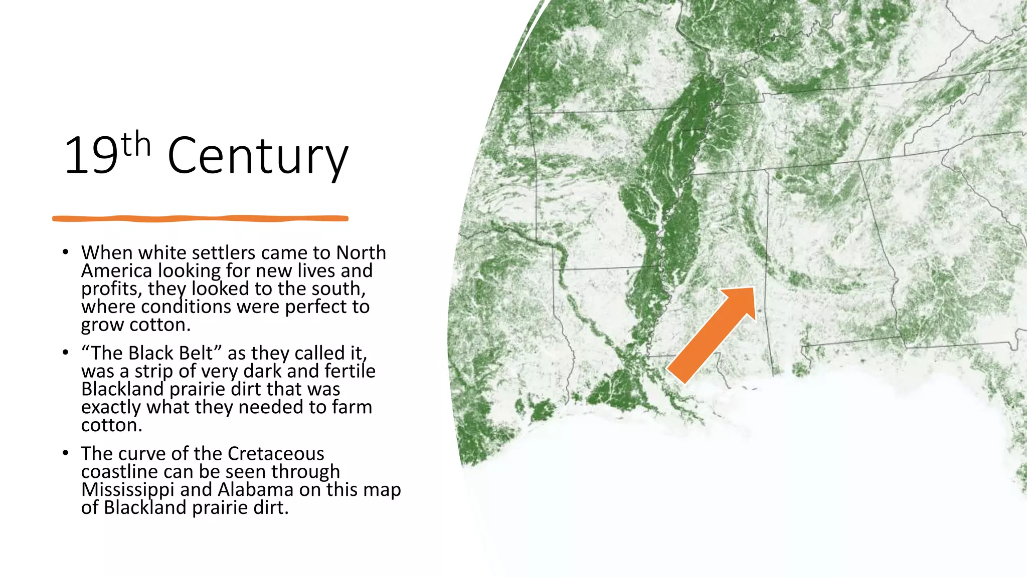
6
Most read
8
Most read
Cretaceous coastlines and
modern voting patterns
The Cretaceous
Period
• 80 million years ago, the Western
Interior Seaway was dividing
America into two continents,
Laramidia (left, west) and
Appalachia (right, east)
• The coastline was several
hundred miles inland compared
to where it is now in the
American southeast.
The Cretaceous
Period
• Through the late Cretaceous, the
Western Interior Seaway slowly
disappeared as the rocky
mountains were forming in
Laramidia, causing a drop in sea
levels.
• The seaway was mostly dried up
65 million years ago, leaving
behind traces of coastlines that
are very rich in limestone and
other sediments good for
farming.
19th Century
• When white settlers came to North
America looking for new lives and
profits, they looked to the south,
where conditions were perfect to
grow cotton.
• “The Black Belt” as they called it,
was a strip of very dark and fertile
Blackland prairie dirt that was
exactly what they needed to farm
cotton.
• The curve of the Cretaceous
coastline can be seen through
Mississippi and Alabama on this map
of Blackland prairie dirt.
19th Century
• Due to this area being very fertile,
slave owners flocked to the area to
stake their claim on the black belt.
• The slave population in the black
belt far surpassed the white
population
• This map shows the density of slaves
per county in the South, the same
distinct curve of the Black Belt can
be seen through Mississippi and
Alabama through the Carolinas.
Modern Day
• After the slaves were emancipated,
many of them stayed in the same areas
where they were originally enslaved.
• Therefore, the “black belt” is now known
for the large African American
population rather than the Blackland
prairie dirt that it was once named for.
• This map from 2000 shows counties in
the south that have a majority African
American Population. It, once again,
follows the same curved outline where
the Cretaceous coastline of Appalachia
once was.
Modern Day
• People of color vote overwhelmingly
democrat in modern political
America. When looking at county-by-
county voting maps for any election,
the pattern of blue follows the same
curved route as the Blackland dirt,
slave population, and ancient
coastline of Appalachia.
• This is how an ancient Cretaceous
coastline has affected modern voting
patterns in the American South.
Modern
Day

More Related Content

PPT
Westward expansion
PPT
Africa, Land of Contrasts
PPT
How Did European Settlement And Expansion In North...
PPTX
Zimbabwe Country Presentation (International Marketing)
PPSX
African American Culture
DOC
African culture
PPTX
Chapter 24 blog notes
PPTX
LESSON 2.2 - EXPLORING THE EARTH'S PAST.pptx
Westward expansion
Africa, Land of Contrasts
How Did European Settlement And Expansion In North...
Zimbabwe Country Presentation (International Marketing)
African American Culture
African culture
Chapter 24 blog notes
LESSON 2.2 - EXPLORING THE EARTH'S PAST.pptx

Similar to Cretaceous Coatlines and Modern Voting Patterns Presentation (11)

PPTX
Geography: Geography of Africa
PPTX
PLATE_TECTONICS_Lesson_06
PPT
Africa the darK continent <---
PPTX
Earlyafrica
PPT
Ch09ed
PPT
Lesson plan geology
PPT
Big geography
PPT
Big history
DOCX
IBM and GE are both in the market for approximately $10 million of.docx
PPT
PPTX
Geology Complete (Earth Science Topic)
Geography: Geography of Africa
PLATE_TECTONICS_Lesson_06
Africa the darK continent <---
Earlyafrica
Ch09ed
Lesson plan geology
Big geography
Big history
IBM and GE are both in the market for approximately $10 million of.docx
Geology Complete (Earth Science Topic)
Ad

More from SERC at Carleton College (20)

PPTX
StatVignette03_Sig.Figs_v04_07_15_2020.pptx
PPTX
StatVignette06_HypTesting.pptx
PPTX
Unit 1 (optional slides)
PPTX
Climate and Biomes PPT 2
PPTX
weather tracking ppt
PPTX
Presentation: Unit 1 Introduction to the hydrological cycle
PPTX
StatVignette05_M3_v02_10_21_2020.pptx
PPTX
KSKL chapter 8 PPT
PPTX
KSKL chap 5 PPT
PPTX
KSKL_Chapter 4_ Chem Properties of Soils.pptx
PPTX
Degraded Soil Images.pptx
PPTX
Educators PPT file chapter 7
PPTX
Educators PPT file chapter 2
PPTX
Educators PPT file chapter 6
PPTX
Educators PPT chapter 3
PPTX
Unit 4 background presentation
PPTX
Presentation: Unit 3 background information
PPTX
Presentation: Unit 2 Measuring Groundwater Background Information
PPTX
Introduction to GPS presentation
PPTX
StatVignette04_Distribution_v04_07_15_2020.pptx
StatVignette03_Sig.Figs_v04_07_15_2020.pptx
StatVignette06_HypTesting.pptx
Unit 1 (optional slides)
Climate and Biomes PPT 2
weather tracking ppt
Presentation: Unit 1 Introduction to the hydrological cycle
StatVignette05_M3_v02_10_21_2020.pptx
KSKL chapter 8 PPT
KSKL chap 5 PPT
KSKL_Chapter 4_ Chem Properties of Soils.pptx
Degraded Soil Images.pptx
Educators PPT file chapter 7
Educators PPT file chapter 2
Educators PPT file chapter 6
Educators PPT chapter 3
Unit 4 background presentation
Presentation: Unit 3 background information
Presentation: Unit 2 Measuring Groundwater Background Information
Introduction to GPS presentation
StatVignette04_Distribution_v04_07_15_2020.pptx
Ad

Cretaceous Coatlines and Modern Voting Patterns Presentation

  • 2. The Cretaceous Period • 80 million years ago, the Western Interior Seaway was dividing America into two continents, Laramidia (left, west) and Appalachia (right, east) • The coastline was several hundred miles inland compared to where it is now in the American southeast.
  • 3. The Cretaceous Period • Through the late Cretaceous, the Western Interior Seaway slowly disappeared as the rocky mountains were forming in Laramidia, causing a drop in sea levels. • The seaway was mostly dried up 65 million years ago, leaving behind traces of coastlines that are very rich in limestone and other sediments good for farming.
  • 4. 19th Century • When white settlers came to North America looking for new lives and profits, they looked to the south, where conditions were perfect to grow cotton. • “The Black Belt” as they called it, was a strip of very dark and fertile Blackland prairie dirt that was exactly what they needed to farm cotton. • The curve of the Cretaceous coastline can be seen through Mississippi and Alabama on this map of Blackland prairie dirt.
  • 5. 19th Century • Due to this area being very fertile, slave owners flocked to the area to stake their claim on the black belt. • The slave population in the black belt far surpassed the white population • This map shows the density of slaves per county in the South, the same distinct curve of the Black Belt can be seen through Mississippi and Alabama through the Carolinas.
  • 6. Modern Day • After the slaves were emancipated, many of them stayed in the same areas where they were originally enslaved. • Therefore, the “black belt” is now known for the large African American population rather than the Blackland prairie dirt that it was once named for. • This map from 2000 shows counties in the south that have a majority African American Population. It, once again, follows the same curved outline where the Cretaceous coastline of Appalachia once was.
  • 7. Modern Day • People of color vote overwhelmingly democrat in modern political America. When looking at county-by- county voting maps for any election, the pattern of blue follows the same curved route as the Blackland dirt, slave population, and ancient coastline of Appalachia. • This is how an ancient Cretaceous coastline has affected modern voting patterns in the American South.