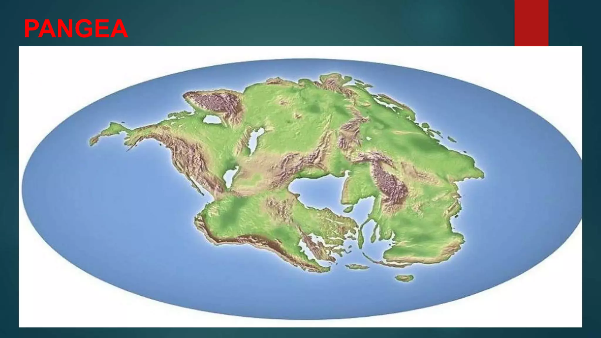
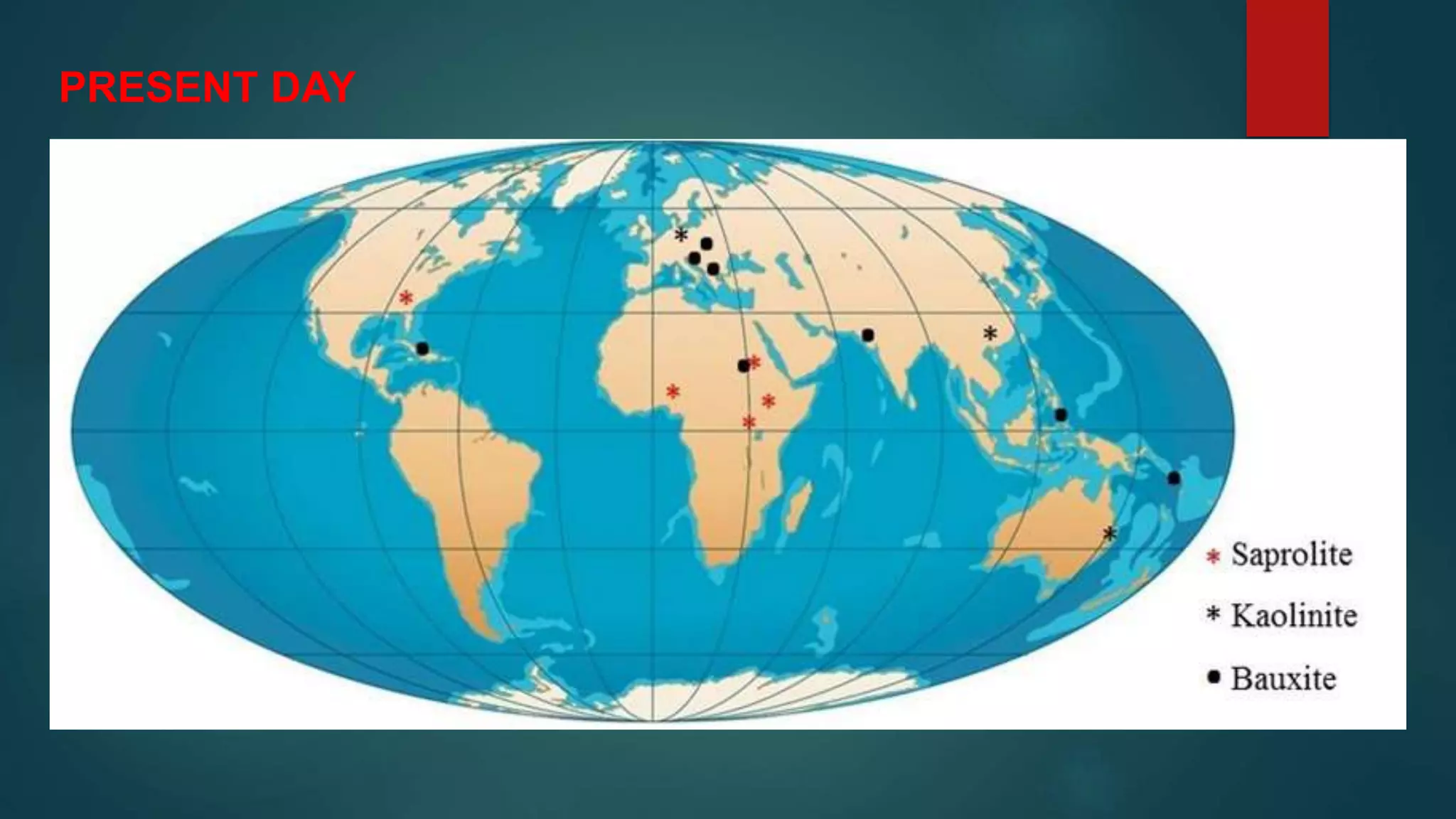
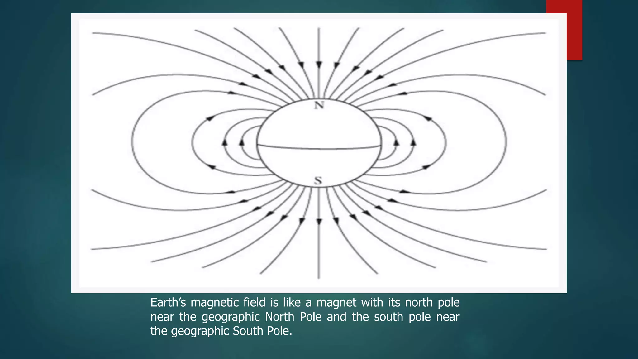
INTERNAL STRUCTURE OF THE EARTH
The Earth's interior is composed of several distinct layers, each with
unique characteristics and properties. These layers are
differentiated based on their composition, physical state, and
behavior. From the outermost layer to the innermost, the Earth's
internal structure consists of the following major layers:
CRUS
T
MANTLE
OUTER CORE
INNER CORE
CRUST- is thin, hard outermost layer of the Earth.
It covers about 0.8 % of the Earth’s volume.
2 Types of Crust
• Oceanic crust- forms the ocean floor and about 8 km thick (made of dense
materials such as basalt and gabbro)
* Continental crust- forms the continent, and about 32 km thick.( consist
primarily of granite and gneiss)
MANTLE- Is the layer between the crust and the core. It is Made partially molten
mixtures of silicate mi9nerals and covers about 84% of the Earth’s volume.
Core –is the Extremely hot, dense center of the Earth’s .
It is composed mainly of nickel-iron alloy. It occupies
about 16% of the Earth’s volume, and is 2900 km thick.
It has a radius of about 3480 km and an average density
of 10.72 gram per cubic centimeter.
The Earth is composed of distinct layers:
1.Crust: The thin outer layer divided into continental and oceanic crust.
Geological activities like earthquakes occur here.
2.Mantle: Beneath the crust, the semi-solid mantle includes the upper
asthenosphere, where tectonic plates move, and the lower mantle.
3.Outer Core: Below the mantle, the liquid outer core of iron and nickel
generates the Earth's magnetic field through convection.
4.Inner Core: At the center, a solid inner core of iron and nickel exists
under extreme pressure, maintained in a solid state due to high
temperature.
These layers interact to shape the Earth's surface, create geological
phenomena, and produce its magnetic field.
THANK YOU
CONTINENTAL DRIFT
Continental drift is a scientific theory that suggests
that the Earth's continents were once part of a
single landmass known as "Pangaea" and have
since drifted apart over millions of years to their
current positions. This theory was proposed by
German meteorologist and geophysicist Alfred
Wegener in the early 20th century, around 1912.
His ideas laid the foundation for the modern
understanding of plate tectonics.
Wegener's theory was based on several lines of
evidence:
1.Fit of the Continents: He noticed that the coastlines
of continents such as South America and Africa seemed
to fit together like pieces of a jigsaw puzzle. This
suggested that they were once connected.
2.Fossil Evidence: Similar fossils of plants and animals
were found on continents that are now widely separated
by oceans. For example, identical plant fossils were
found in South America and Africa, which implies that
these continents were once joined.
3. Rock and Mountain Range Similarities:
Wegener noted that certain rock formations and
mountain ranges appeared to continue from one
continent to another, even though they are now
separated by vast oceans.
4. Glacier Evidence: Evidence of past glaciers
and ice sheets has found region that are now two
warm to such formations. Wegener proposed,
that these regions was once part of a larger
landmass located in the different positions in the
TIMELINE OF ALFRED WEGENER
Alfred Wegener, in full Alfred Lothar
Wegener, (born November 1, 1880,
Berlin, Germany—died November 1930,
Greenland), German meteorologist and
geophysicist who formulated the first
complete statement of the continental
drift hypothesis.
The son of an orphanage director, Wegener earned a
Ph.D. degree in astronomy from the University
of Berlin in 1905. He had meanwhile become
interested in paleoclimatology, and in 1906–08 he
took part in an expedition to Greenland to study
polar air circulation. On this trip he befriended
German climatologist Wladimir Köppen, who
became his mentor, and later married Köppen’s
daughter, Elsa, in 1913. He made three more
expeditions to Greenland, in 1912–13, 1929, and
1930.
He taught meteorology at Marburg and
Hamburg and was a professor of
meteorology and geophysics at the
University of Graz from 1924 to 1930.
He died during his last expedition to
Greenland in 1930.
Like certain other scientists before him, Wegener became impressed
with the similarity in the coastlines of eastern South America and
western Africa and speculated that those lands had once been joined
together. About 1910 he began toying with the idea that in the
late Paleozoic Era (which ended about 252 million years ago) all the
present-day continents had formed a single large mass,
or supercontinent, which had subsequently broken apart. Wegener
called this ancient continent Pangaea. Other scientists had proposed
such a continent but had explained the separation of the modern
world’s continents as having resulted from the subsidence, or sinking, of
large portions of the supercontinent to form
the Atlantic and Indian oceans. Wegener, by contrast, proposed that
Pangaea’s constituent portions had slowly moved thousands of miles
apart over long periods of geologic time. His term for this movement
was die Verschiebung der Kontinente (“continental displacement”),
which gave rise to the term continental drift.
Wegener first presented his theory in lectures in 1912
and published it in full in 1915 in his most important
work, Die Entstehung der Kontinente und Ozeane (The
Origin of Continents and Oceans). He searched the
scientific literature for geological and paleontological
evidence that would buttress his theory, and he was
able to point to many closely related fossil organisms
and similar rock strata that occurred on widely
separated continents, particularly those found in
both the Americas and in Africa.
Wegener’s theory of continental drift won some
adherents in the ensuing decade, but his
postulations of the driving forces behind the
continents’ movement seemed implausible. By
1930 his theory had been rejected by most
geologists, and it sank into obscurity for the
next few decades, only to be resurrected as part
of the theory of plate tectonics during the
1960s.
PANGEA
PRESENT DAY
INTRODUCTION
The continental drift hypothesis was developed
in the early part of the 20th century, mostly by
Alfred Wegener. Wegener said that continents
move around on Earth’s surface and that they
were once joined together as a single
supercontinent. While Wegener was alive,
scientists did not believe that the continents
could move.
THE CONTINENTAL
DRIFT IDEA
Find a map of the continents and cut
each one out. Better yet, use a map
where the edges of the continents
show the continental shelf. That’s the
true size and shape of a continent.
Can you fit the pieces together? The
easiest link is between the eastern
Americas and western Africa and
Europe, but the rest can fit together
too
The continents fit together like pieces of a
puzzle. This is how they looked 250 million
years ago.
Alfred Wegener proposed that the continents were once united into
a single supercontinent named Pangaea, meaning all earth in
ancient Greek. He suggested that Pangaea broke up long ago and
that the continents then moved to their current positions. He called
his hypothesis continental drift.
EVIDENCE FOR CONTINENTAL DRIFT
Besides the way the continents fit together, Wegener and
his supporters collected a great deal of evidence for the
continental drift hypothesis.
The similarities between the Appalachian and the
eastern Greenland mountain ranges are evidences
for the continental drift hypothesis.
 Ancient fossils of the same species of extinct plants and animals are
found in rocks of the same age but are on continents that are now
widely separated (see next figure). Wegener proposed that the
organisms had lived side by side, but that the lands had moved apart
after they were dead and fossilized. He suggested that the
organisms would not have been able to travel across the oceans.
o Fossils of the seed fern Glossopteris were too heavy to be carried
so far by wind.
o Mesosaurus was a swimming reptile but could only swim in fresh
water.
o Cynognathus and Lystrosaurus were land reptiles and were unable
to swim
. Wegener used fossil evidence to support his
continental drift hypothesis. The fossils of these
organisms are found on lands that are now far
apart.
 Grooves and rock deposits left by ancient glaciers are found
today on different continents very close to the equator. This
would indicate that the glaciers either formed in the middle of
the ocean and/or covered most of the Earth. Today glaciers only
form on land and nearer the poles. Wegener thought that the
glaciers were centered over the southern land mass close to the
South Pole and the continents moved to their present positions
later on.
 Coral reefs and coal-forming swamps are found in tropical and
subtropical environments, but ancient coal seams and coral reefs
are found in locations where it is much too cold today. Wegener
suggested that these creatures were alive in warm climate zones
and that the fossils and coal later had drifted to new locations on
the continents.
Take a look at this animation showing that
Earth’s climate belts remain in roughly the same
position while the continents move and this
animation showing how the continents split up.
Although Wegener’s evidence was sound, most
geologists at the time rejected his hypothesis of
continental drift. Why do you think they did not
accept continental drift?
Scientists argued that there was no way to explain how solid continents
could plow through solid oceanic crust. Wegener’s idea was nearly
forgotten until technological advances presented even more evidence
that the continents moved and gave scientists the tools to develop a
mechanism for Wegener’s drifting continents.
MAGNETIC POLARITY EVIDENCE
Puzzling new evidence came in the 1950s from studies on the Earth’s
magnetic history (figure 4). Scientists used magnetometers, devices
capable of measuring the magnetic field intensity, to look at the
magnetic properties of rocks in many locations.
Earth’s magnetic field is like a magnet with its north pole
near the geographic North Pole and the south pole near
the geographic South Pole.
Magnetite crystals are like tiny magnets that point to the
north magnetic pole as they crystallize from magma. The
crystals record both the direction and strength of
the magnetic field at the time. The direction is known as
the field’s magnetic polarity.
Magnetic Polarity on the Same Continent with Rocks
of Different Ages
Geologists noted important things about the magnetic
polarity of different aged rocks on the same continent:
•Magnetite crystals in fresh volcanic rocks point to the
current magnetic north pole (figure 5) no matter what
continent or where on the continent the rocks are located.
Earth’s current north magnetic pole is in
northern Canada.
•Older rocks that are the same age and are located on
the same continent point to the same location, but that
location is not the current north magnetic pole.
•Older rock that are of different ages do not point to
the same locations or to the current magnetic north
pole.
In other words, although the magnetite crystals were
pointing to the magnetic north pole, the location of the
pole seemed to wander. Scientists were amazed to find
that the north magnetic pole changed location through
time
The location of the north
magnetic north pole 80
million years before
present (mybp), then 60,
40, 20, and now.
There are three possible explanations for this:
1.The continents remained fixed and the north magnetic
pole moved.
2.The north magnetic pole stood still and the continents
moved.
3.Both the continents and the north pole moved.
Magnetic Polarity on Different Continents with
Rocks of the Same Age
Geologists noted that for rocks of the same age but
on different continents, the little magnets pointed to
different magnetic north poles.
•400-million-year-old magnetite in Europe pointed to
a different north magnetic pole than the same-aged
magnetite in North America.
•250 million years ago, the north poles were also
different for the two continents.
The scientists looked again at the three possible explanations.
Only one can be correct. If the continents had remained fixed
while the north magnetic pole moved, there must have been
two separate north poles. Since there is only one north pole
today, the only reasonable explanation is that the north
magnetic pole has remained fixed but that the continents
have moved.
To test this, geologists fitted the continents together as
Wegener had done. It worked! There has only been one
magnetic north pole and the continents have drifted (figure
7). They named the phenomenon of the magnetic pole that
seemed to move but actually did not apparent polar
wander.
On the left: The apparent north pole for Europe and
North America if the continents were always in their
current locations. The two paths merge into one if the
continents are allowed to drift.
This evidence for continental drift gave geologists renewed interest in
understanding how continents could move about on the planet’s
surface.
LESSON SUMMARY
•In the early part of the 20th century, scientists began to put together
evidence that the continents could move around on Earth’s surface.
•The evidence for continental drift included the fit of the continents;
the distribution of ancient fossils, rocks, and mountain ranges; and the
locations of ancient climatic zones.
•Although the evidence for continental drift was extremely strong,
scientists rejected the idea because no mechanism for how solid
continents could move around on the solid earth was developed.
•The discovery of apparent polar wander renewed scientists interest in
continental drift.

Integ Sci 10 Lesson 1 [Autosaved].pptx

  • 1.
    INTERNAL STRUCTURE OFTHE EARTH The Earth's interior is composed of several distinct layers, each with unique characteristics and properties. These layers are differentiated based on their composition, physical state, and behavior. From the outermost layer to the innermost, the Earth's internal structure consists of the following major layers:
  • 2.
  • 3.
    CRUST- is thin,hard outermost layer of the Earth. It covers about 0.8 % of the Earth’s volume. 2 Types of Crust • Oceanic crust- forms the ocean floor and about 8 km thick (made of dense materials such as basalt and gabbro) * Continental crust- forms the continent, and about 32 km thick.( consist primarily of granite and gneiss) MANTLE- Is the layer between the crust and the core. It is Made partially molten mixtures of silicate mi9nerals and covers about 84% of the Earth’s volume. Core –is the Extremely hot, dense center of the Earth’s . It is composed mainly of nickel-iron alloy. It occupies about 16% of the Earth’s volume, and is 2900 km thick. It has a radius of about 3480 km and an average density of 10.72 gram per cubic centimeter.
  • 4.
    The Earth iscomposed of distinct layers: 1.Crust: The thin outer layer divided into continental and oceanic crust. Geological activities like earthquakes occur here. 2.Mantle: Beneath the crust, the semi-solid mantle includes the upper asthenosphere, where tectonic plates move, and the lower mantle. 3.Outer Core: Below the mantle, the liquid outer core of iron and nickel generates the Earth's magnetic field through convection. 4.Inner Core: At the center, a solid inner core of iron and nickel exists under extreme pressure, maintained in a solid state due to high temperature. These layers interact to shape the Earth's surface, create geological phenomena, and produce its magnetic field.
  • 6.
  • 7.
    CONTINENTAL DRIFT Continental driftis a scientific theory that suggests that the Earth's continents were once part of a single landmass known as "Pangaea" and have since drifted apart over millions of years to their current positions. This theory was proposed by German meteorologist and geophysicist Alfred Wegener in the early 20th century, around 1912. His ideas laid the foundation for the modern understanding of plate tectonics.
  • 8.
    Wegener's theory wasbased on several lines of evidence: 1.Fit of the Continents: He noticed that the coastlines of continents such as South America and Africa seemed to fit together like pieces of a jigsaw puzzle. This suggested that they were once connected. 2.Fossil Evidence: Similar fossils of plants and animals were found on continents that are now widely separated by oceans. For example, identical plant fossils were found in South America and Africa, which implies that these continents were once joined.
  • 9.
    3. Rock andMountain Range Similarities: Wegener noted that certain rock formations and mountain ranges appeared to continue from one continent to another, even though they are now separated by vast oceans. 4. Glacier Evidence: Evidence of past glaciers and ice sheets has found region that are now two warm to such formations. Wegener proposed, that these regions was once part of a larger landmass located in the different positions in the
  • 10.
    TIMELINE OF ALFREDWEGENER Alfred Wegener, in full Alfred Lothar Wegener, (born November 1, 1880, Berlin, Germany—died November 1930, Greenland), German meteorologist and geophysicist who formulated the first complete statement of the continental drift hypothesis.
  • 11.
    The son ofan orphanage director, Wegener earned a Ph.D. degree in astronomy from the University of Berlin in 1905. He had meanwhile become interested in paleoclimatology, and in 1906–08 he took part in an expedition to Greenland to study polar air circulation. On this trip he befriended German climatologist Wladimir Köppen, who became his mentor, and later married Köppen’s daughter, Elsa, in 1913. He made three more expeditions to Greenland, in 1912–13, 1929, and 1930.
  • 12.
    He taught meteorologyat Marburg and Hamburg and was a professor of meteorology and geophysics at the University of Graz from 1924 to 1930. He died during his last expedition to Greenland in 1930.
  • 13.
    Like certain otherscientists before him, Wegener became impressed with the similarity in the coastlines of eastern South America and western Africa and speculated that those lands had once been joined together. About 1910 he began toying with the idea that in the late Paleozoic Era (which ended about 252 million years ago) all the present-day continents had formed a single large mass, or supercontinent, which had subsequently broken apart. Wegener called this ancient continent Pangaea. Other scientists had proposed such a continent but had explained the separation of the modern world’s continents as having resulted from the subsidence, or sinking, of large portions of the supercontinent to form the Atlantic and Indian oceans. Wegener, by contrast, proposed that Pangaea’s constituent portions had slowly moved thousands of miles apart over long periods of geologic time. His term for this movement was die Verschiebung der Kontinente (“continental displacement”), which gave rise to the term continental drift.
  • 14.
    Wegener first presentedhis theory in lectures in 1912 and published it in full in 1915 in his most important work, Die Entstehung der Kontinente und Ozeane (The Origin of Continents and Oceans). He searched the scientific literature for geological and paleontological evidence that would buttress his theory, and he was able to point to many closely related fossil organisms and similar rock strata that occurred on widely separated continents, particularly those found in both the Americas and in Africa.
  • 15.
    Wegener’s theory ofcontinental drift won some adherents in the ensuing decade, but his postulations of the driving forces behind the continents’ movement seemed implausible. By 1930 his theory had been rejected by most geologists, and it sank into obscurity for the next few decades, only to be resurrected as part of the theory of plate tectonics during the 1960s.
  • 16.
  • 18.
  • 19.
    INTRODUCTION The continental drifthypothesis was developed in the early part of the 20th century, mostly by Alfred Wegener. Wegener said that continents move around on Earth’s surface and that they were once joined together as a single supercontinent. While Wegener was alive, scientists did not believe that the continents could move.
  • 20.
    THE CONTINENTAL DRIFT IDEA Finda map of the continents and cut each one out. Better yet, use a map where the edges of the continents show the continental shelf. That’s the true size and shape of a continent. Can you fit the pieces together? The easiest link is between the eastern Americas and western Africa and Europe, but the rest can fit together too The continents fit together like pieces of a puzzle. This is how they looked 250 million years ago.
  • 21.
    Alfred Wegener proposedthat the continents were once united into a single supercontinent named Pangaea, meaning all earth in ancient Greek. He suggested that Pangaea broke up long ago and that the continents then moved to their current positions. He called his hypothesis continental drift. EVIDENCE FOR CONTINENTAL DRIFT Besides the way the continents fit together, Wegener and his supporters collected a great deal of evidence for the continental drift hypothesis.
  • 22.
    The similarities betweenthe Appalachian and the eastern Greenland mountain ranges are evidences for the continental drift hypothesis.
  • 23.
     Ancient fossilsof the same species of extinct plants and animals are found in rocks of the same age but are on continents that are now widely separated (see next figure). Wegener proposed that the organisms had lived side by side, but that the lands had moved apart after they were dead and fossilized. He suggested that the organisms would not have been able to travel across the oceans. o Fossils of the seed fern Glossopteris were too heavy to be carried so far by wind. o Mesosaurus was a swimming reptile but could only swim in fresh water. o Cynognathus and Lystrosaurus were land reptiles and were unable to swim
  • 24.
    . Wegener usedfossil evidence to support his continental drift hypothesis. The fossils of these organisms are found on lands that are now far apart.
  • 25.
     Grooves androck deposits left by ancient glaciers are found today on different continents very close to the equator. This would indicate that the glaciers either formed in the middle of the ocean and/or covered most of the Earth. Today glaciers only form on land and nearer the poles. Wegener thought that the glaciers were centered over the southern land mass close to the South Pole and the continents moved to their present positions later on.  Coral reefs and coal-forming swamps are found in tropical and subtropical environments, but ancient coal seams and coral reefs are found in locations where it is much too cold today. Wegener suggested that these creatures were alive in warm climate zones and that the fossils and coal later had drifted to new locations on the continents.
  • 26.
    Take a lookat this animation showing that Earth’s climate belts remain in roughly the same position while the continents move and this animation showing how the continents split up. Although Wegener’s evidence was sound, most geologists at the time rejected his hypothesis of continental drift. Why do you think they did not accept continental drift?
  • 27.
    Scientists argued thatthere was no way to explain how solid continents could plow through solid oceanic crust. Wegener’s idea was nearly forgotten until technological advances presented even more evidence that the continents moved and gave scientists the tools to develop a mechanism for Wegener’s drifting continents. MAGNETIC POLARITY EVIDENCE Puzzling new evidence came in the 1950s from studies on the Earth’s magnetic history (figure 4). Scientists used magnetometers, devices capable of measuring the magnetic field intensity, to look at the magnetic properties of rocks in many locations.
  • 28.
    Earth’s magnetic fieldis like a magnet with its north pole near the geographic North Pole and the south pole near the geographic South Pole.
  • 29.
    Magnetite crystals arelike tiny magnets that point to the north magnetic pole as they crystallize from magma. The crystals record both the direction and strength of the magnetic field at the time. The direction is known as the field’s magnetic polarity. Magnetic Polarity on the Same Continent with Rocks of Different Ages Geologists noted important things about the magnetic polarity of different aged rocks on the same continent: •Magnetite crystals in fresh volcanic rocks point to the current magnetic north pole (figure 5) no matter what continent or where on the continent the rocks are located.
  • 30.
    Earth’s current northmagnetic pole is in northern Canada.
  • 31.
    •Older rocks thatare the same age and are located on the same continent point to the same location, but that location is not the current north magnetic pole. •Older rock that are of different ages do not point to the same locations or to the current magnetic north pole. In other words, although the magnetite crystals were pointing to the magnetic north pole, the location of the pole seemed to wander. Scientists were amazed to find that the north magnetic pole changed location through time
  • 32.
    The location ofthe north magnetic north pole 80 million years before present (mybp), then 60, 40, 20, and now.
  • 33.
    There are threepossible explanations for this: 1.The continents remained fixed and the north magnetic pole moved. 2.The north magnetic pole stood still and the continents moved. 3.Both the continents and the north pole moved.
  • 34.
    Magnetic Polarity onDifferent Continents with Rocks of the Same Age Geologists noted that for rocks of the same age but on different continents, the little magnets pointed to different magnetic north poles. •400-million-year-old magnetite in Europe pointed to a different north magnetic pole than the same-aged magnetite in North America. •250 million years ago, the north poles were also different for the two continents.
  • 35.
    The scientists lookedagain at the three possible explanations. Only one can be correct. If the continents had remained fixed while the north magnetic pole moved, there must have been two separate north poles. Since there is only one north pole today, the only reasonable explanation is that the north magnetic pole has remained fixed but that the continents have moved. To test this, geologists fitted the continents together as Wegener had done. It worked! There has only been one magnetic north pole and the continents have drifted (figure 7). They named the phenomenon of the magnetic pole that seemed to move but actually did not apparent polar wander.
  • 36.
    On the left:The apparent north pole for Europe and North America if the continents were always in their current locations. The two paths merge into one if the continents are allowed to drift.
  • 37.
    This evidence forcontinental drift gave geologists renewed interest in understanding how continents could move about on the planet’s surface. LESSON SUMMARY •In the early part of the 20th century, scientists began to put together evidence that the continents could move around on Earth’s surface. •The evidence for continental drift included the fit of the continents; the distribution of ancient fossils, rocks, and mountain ranges; and the locations of ancient climatic zones. •Although the evidence for continental drift was extremely strong, scientists rejected the idea because no mechanism for how solid continents could move around on the solid earth was developed. •The discovery of apparent polar wander renewed scientists interest in continental drift.